Maeldune - Light on Maldon's Distant Past
|
THE FIRST MALDONIANSPaul N Brown |

|
JOIN us on a journey back through time to the last great Ice Age, some 18,000 years ago. The earth is frozen solid and the landscape bleak and swept by icy winds. Only mammoths and similarly adapted animals can survive here for any length of time although others are attracted when the the dormant flora bursts into life during the fleeting summer weeks. Every year reindeer herds migrate long distances to graze on the cool fresh pasture-land. It is quite likely that the first humans of our own species to be seen in the vicinity of Maldon were hardy nomadic hunters determined to follow these reindeer to the very 'edge of the world' in order to survive. There is no resemblance to the 20th century landscape and the sea is a long way off. Britain is not yet an island and will not be cut off from France for another 10,000 years.
The ice sheets which had dominated this part of the globe for 50,000 years were retreating for the last time and gradually the vast open landscape became overgrown with birch and pine forests, not at all suitable for reindeer or the hunters who depended so heavily upon them. Around 8000BC the great polar ice caps shrank so swiftly and to such an extent that a worldwide rise in sea level took place. The climate in Britain continued to become wetter and warmer causing another change to the vegetation cover. Deciduous trees such as oak, alder and elm became established and eventually took over altogether from the thick pine forests. The tract of land which linked Britain with France at this time provided a good habitat for the forest adapted hunter of the day. When the waves eventually cut off Britain from the continent around 7000BC many sites must have been covered over by the sea. Occasionally artefacts from these Mesolithic sites are brought to the surface in trawlermen's nets.
Living as we do in the age of the motorway and satellite television, it is not easy to understand the world and lives of earlier generations. This, after all, should be the aim of archaeology and the extent of our understanding, the measure of its success. The River Chelmer traverses the heart of Essex and is joined by the River Blackwater to form a wide estuary before flowing into the sea. The river must have always been of great importance to the people of Essex and many occupation sites along its length from all periods are evident. Its fertile valley sustained the inhabitants, provided a communication route and a natural boundary. Maldon, at the mouth, would naturally acquire importance. The rich alluvial topsoil affords good farm land and the tidal estuary is suitable for extracting salt from the sea and a haven for sea travellers and traders. In unsettled times the large hill top provided both a vantage point and a defendable refuge.
Another change which obscures our view of the pre-991 landscape is the sea wall and associated land reclamation. In the disastrous 1953 floods the wall was breached at Mill Beach and water rushed a long way inland. Prior to the first sea wall defences, believed to be in the 13th century, large scale flooding of the River valley must have been quite common, determining the type and positioning of permanent dwellings. Climatic changes over the centuries have caused the general sea level to both rise and fall for quite long periods. We might expect to find a correlation of site positions above sea level with these fluctuations.
The underlying subsoil around Maldon is variable, but north of the town and river estuary is predominantly gravel terrace, deposited by the melting glaciers of the last Ice Age more than ten thousand years ago. It supports a well drained fertile topsoil favoured by the earliest and subsequent settlers and farmers alike. Archaeological aerial photography is particularly effective over gravel. Ancient and 'lost' landscapes can be plotted by tracing the lines and circles which appear in crops, as if by magic, at certain times of the year. Sadly very little of this new found wealth of archaeology is likely to survive the 20th century. Due to the increasing value of gravel as a commodity and the shallow depth of local deposits, quarrying has extended rapidly across the countryside. Most areas are later being restored to farm land but the archaeology can never be replaced.
Some of the lower lying areas of gravel are covered by a layer of brickearth, a fine silty loam called loess which effectively blots out archaeological crop marks but still provides very fertile farm land.
South of the river estuary London Clay predominates. Farmers not only had to deal with a much 'heavier' soil to plough but also with drainage problems. The impermeable nature of the soil causes waterlogging wherever there is no natural slope or drainage. It is equally unfriendly to archaeologists who are unable to glean much information at all from aerial photography.
In some areas, especially close to the town itself, clay and gravel are mixed in patches, although clay is the most common.
The oldest objects encountered by MAG have been large animal bones and fragments of mammoth tusk. These were dredged up by quarry machinery from large black deposits lying below the gravel at Lofts Farm. Although not linked with any human evidence they did serve to remind us of the countless millennia preceding the close of the last Ice Age.
FIRST MALDON SETTLERS
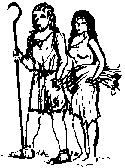
The earliest man-made, and therefore archaeological, artefacts discovered are the long lost flint tools of nomadic Mesolithic hunter gatherers who camped in areas where natural resources ensured a good food supply. The Chelmer and Blackwater rivers with their fertile flood plains provided just such an environment. In Britain the Mesolithic period, meaning 'middle stone age', is considered to extend from the end of the last Ice Age, about 10,000BC, down to the Neolithic, or 'new stone age' starting around 4000BC. Many of the hunters' distinctive flints have been found scattered along the river banks as well as from archaeological excavations.
Evidence of the earliest settlers and farmers of the Neolithic period is even more plentiful. Small pits with flint blades, scrapers and pottery have been so frequently identified on river valley excavations that it seems that any reasonably sized area stripped of topsoil will produce Neolithic features of some kind. Most have been discovered in the course of excavating an archaeological site of a much later period.
When considering the length of the Neolithic period (4000BC-2000BC) it is hardly surprising that successive generations, dependent on the same favourable fertile soil, have left so much for us to find.
Several small cooking holes, pits and a length of ditch were found by Maldon Archaeological Group volunteers during excavations around Lofts Farm, Great Totham. The pottery from one group of pits indicated a date as early as 3500BC. More substantial settlement evidence has recently come from two nearby sites, The Stumbles and Slough House Farm, excavated by Essex County Council archaeologists.
In Essex we do not have impressive upstanding stone monuments such as Stonehenge or Avebury rings; however, recent excavations coupled with the close scrutiny of aerial crop mark photographs show the presence of large Neolithic features. Two ECC excavated examples are the Orsett Cock causewayed enclosure and the Springfield Cursus. The latter, stretched out along the Chelmer Valley, must have been of importance to contemporary inhabitants of the Maldon area. The failure of such large monuments to survive above ground is due to the absence of stone building material and also to the intensity of subsequent land use.
BRONZE AGE 2000-600BC
It is difficult and undesirable to compare sites and places in geographical isolation and sharply to divide archaeological periods. With the coming of the Bronze Age we see new types of archaeological evidence evolving over a period of several hundred years. It is unlikely that bronze played any part in the lives of farmers at the beginning of the 2nd millennium BC but we have found examples of flintwork indicating that their lives may not have been any different from their stone age predecessors.
The most obvious Bronze Age evidence is the appearance of Barrow burials. Hundreds have been identified across Essex purely from aerial photographs. At Lofts Farm two known ring ditches were examined and others discovered in the course of a rescue excavation project. The largest excavated 'Barrow', just north of the present Lofts farmhouse, had originated around 1750BC and was used for a succession of Bronze Age burials. It survived as a landscape feature for nearly 2,000 years until it was flattened by Roman farm workers altering a field layout.
There appears to have been an intensification of land use and organisation which was probably the result of population increase and social organisation. Trackways and land boundaries became of greater significance, some of which survive as the skeleton of our 20th century landscape.
We have examples of beaker and corded bucket urn pottery at Lofts and Slough House Farms which represent a departure from round-bottomed Neolithic vessels and the introduction of new decorative styles.
The Late Bronze Age Early Iron Age is the unimaginative title applied by archaeologists to a period of great significance to the development of this area. For the first time ever, a sizable community made the Maldon hill top their home.
At the beginning of the first millennium BC numerous palisaded hill top settlements developed in a similar way right across southern Britain. In many instances, between 750 and 500BC, these evolved into hillforts with impressive ramparts and large ditches. So far there has been no evidence of ramparts or ditches from this period around Maldon but it is reasonable to assume that the natural steep gradients around the hill performed a similar defensive function for the first inhabitants and therefore in the Early Iron Age Maldon should be regarded as a hillfort.
EARLY IRON AGE 600-300BC
Defence was surely an important consideration in the lives of the people of these times. Danbury's hill top was also occupied in the Early Iron Age although, like Maldon, there is only limited evidence of defensive earthworks. Slightly further up the Chelmer valley at Springfield Lyons a circular enclosure, defended by a large ditch and bank, occupied another elevated strategic position. A site of similar shape and size to Springfield Lyons, with an unrivalled view of the Dengie peninsular is Purleigh Mound, a scheduled Ancient Monument. The meagre evidence so far from this site suggests an early medieval motte or small castle mound but a much earlier Bronze Age origin is possible.
If we look to the east and a little further away we can also see Early Iron Age evidence on the top and upper slopes of Sheepen hill, which was to become the core of pre-Roman Colchester.
Although they are rarely recognised, lowland sites certainly existed and a double ditched rectangular enclosure with internal structures was jointly excavated by Maldon Archaeological Group and Essex County Council as the last phase of Lofts Farm rescue excavation project.
The Blackwater river estuary, surrounding salt marsh, an underlying clay bed and favourable prevailing winds makes this an ideal area for the extraction of sea salt. This is another activity which originated in the Bronze Age and continues today. The techniques employed are likely to be similar to those deduced from the excavation of later Iron Age and Roman sites at Osea Road, Peldon and Tollesbury.
Clay was extracted from the river bed and puddled into 'pans' to form evaporation tanks about 1 metre in diameter. The pans were positioned so as to be filled at high tide. Natural evaporation then converted the pan water to a salty brine. The next stage was to transfer the brine to large coarse fired rectangular vessels where the final evaporation by heating over an open oven produced the salt crystals.
The process would have been seasonal and repeated by generation after generation on the same sites. The coarse vessels and fired clay bars required to support them over ovens did not last very long and making replacements would have represented a large part of the work. Over the years broken vessel fragments and the repeated firing of clay ovens built up into red mounds and these are known to us as Red Hills and the broken fragments as bricketage.
The salt marsh was also exploited seasonally in other ways such as the grazing of animals. Droveways were required for the movement of herds and access to grazing areas. The people cultivating crops in fields close to the estuary would not have welcomed interference by passing herds and it would have been in their own interest to ensure trackways were kept clear.
Large wells and watering holes were common and examples at Lofts Farm and Chigborough Farm rescue excavations have contained detailed environmental evidence together with useful groups of distinctive pottery sherds.
Cemeteries, defensive earthworks, red hills and trackways are fairly numerous and readily identified in the landscape. The settlement sites and their buildings, however, are more difficult to trace.
Few Bronze age houses have been found or excavated in Essex largely due to our inability to recognise small post-hole structures from aerial photographs and to identify circles from a mass of post-holes caused by continual rebuilding. Of the buildings that have been identified, most are round houses constructed with posts set vertically in the ground and often showing evidence of much rebuilding. Many more huts which existed in these times did not disturb the subsoil and are therefore impossible for us to locate in rescue archaeology. At Lofts Farm one or two apparently isolated small wells were recorded. These were much too small to be for livestock and are perhaps the only archaeological evidence surviving from a short lived prehistoric farmstead.
MIDDLE IRON AGE 300-100BC
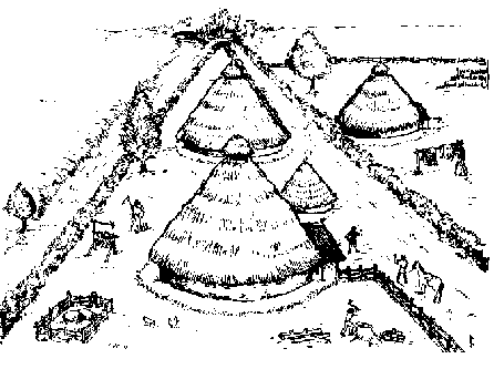
Little evidence from this period has been found on Maldon's hilltop although open farmsteads abound on the surrounding gravel terraces. They were scattered across a man managed landscape of trackways and fields dispersed at a frequency little different from farms of today. The open nature of the settlements and absence of hilltop activity suggests a long period of stability when self sufficient farming families could really make the most of the surrounding natural resources. Small domestic objects such as spindle whorls and loom weights found at Lofts Farm add colour to our picture of these farming people in their round houses.
|
| Artist's impression of a typical farming settlement of the Middle and Late Iron Age. |
The pottery they used was handmade and rarely decorated with anything more than simple finger impressions on the rim. The house doorways were usually positioned on the east side and it is around these that we find most broken sherds and domestic rubbish.
The acidic soil of these gravel sites quickly dissolves all organic material such as wood and bone and so, some 2,000 years later, we do not get a complete range of everyday Iron Age objects.
At Lofts Farm we recorded sixteen ring-ditches representing an assortment of round house building styles. A plan showing all these features seems to indicate a small Iron Age village, similar to the one at Little Waltham, but this is misleading. In fact these buildings would have spanned some two hundred years and so at any one time only two or three would have existed together.
LATE IRON AGE 100BC-43AD
Thanks to Roman writers we at last have 'real' names for British tribes and important individuals. We have moved into proto-historic times. From these sources it is possible to piece together a sketchy view of the politics of pre-Roman Britain.
The origin of the various tribes is not at all clear. Many evolved from small local communities merging to become larger groups. The most powerful and influential tribe of all, the Catuvellauni of Hertfordshire, is thought to have developed in this way.
In Essex the Trinovantes seem to have been long-established, as were their northern neighbours, the Iceni. When Caesar led five legions and 2,000 cavalry in a campaign across the Channel in 54BC he was opposed by an alliance of British tribes. Following defeats in several engagements the alliance crumbled and the Trinovantes, who had previously suffered from Catuvellaunian aggression, were the first to make peace with the Romans.
Tribes often minted their own coinage and distribution evidence is important to the archaeologist. A British potin coin was found during excavations at Heybridge in 1972. Although coins are rarely found, most of the Late Iron Age sites around Maldon provide ample evidence of the Roman influence. As the Roman world expanded so did the desire for Roman goods and products. Increasing trade coupled with high export taxes ensured growing wealth for Imperial Rome. Generally this healthy trading situation suited Rome but, as and when necessary, military might was applied to bring independent operators into line. Caesar's 55 & 54BC incursions into Britain can be viewed in this way. It was not necessary to annex a country while the export trade flourished.
In order to acquire Roman luxuries it became necessary for the resident Britons to have produce with which to trade. Captured slaves ( hapless neighbours!!) could have been exchanged for flagons of wine but arranging repeat orders would have become more and more difficult. Increased salt production would be a more acceptable occupation. Another important means of producing a useful surplus would have been the clearance and cultivation of new fields. The most fertile land, such as the gravel terraces to the north of Maldon had already been fully exploited for centuries but the more difficult clay soils to the south had been avoided. More efficient farm implements had been developed by the Romans and the technological advances may have been brought across the Channel to help the pre-Roman farmer break new ground.
The farm settlement recently discovered on the line of Maldon's Southern Relief Road may well have been home and base for some of the first Dengie farmers, people who brought arable farming to the difficult clays of the Dengie peninsular for the first time in response to the desire to trade with the Roman world.
By this time Heybridge had become a port and haven in the service of important trade activities, not only for the Maldon area but also for the well populated Chelmer and Blackwater River valleys. Around Lofts Farm we see farming continuing very much as it had done during earlier centuries with fields, trackways and natural brooks dominating the landscape.
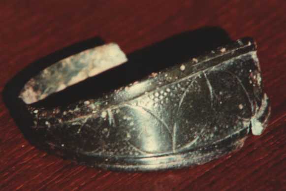
One surprising discovery at Lofts Farm contrasts with the mass of rural evidence. This consisted of a small hoard of bronze objects which included a decorated bronze ring and several 'V' shaped fragments. Precise dating of these objects has been difficult to determine but around 50BC seems most likely.
|
The 'V' shaped fragments
were once thought to have been sword chapes (reinforcements
for sword scabbards) because of their similarity to some
Roman types. Two recent discoveries from distant sites
now allow us to identify the fragments as the metal
edging of Iron Age shields. They were approximately
elliptical in shape but with the top and bottom turned
inward to form a point in each 'corner'. The seven or so
'V' shapes from the Lofts Farm hoard represent the
remains of at least two such shields.
The ring, which at 15mm diameter is too large to have been a finger ring, does not appear to have any parallels. |
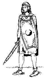
Reconstruction drawing showing the type of shield represented by the Lofts Farm bronze fragments. |
How such interesting finds became hidden in a small hole next to the ruin of a roundhouse just south of a fork in a trackway is a real mystery. Was it a bronze-smith's secret store? Was it identifiable loot, too hot to handle, buried where no one would ever find it? We will never know.
A small rectangular cropmark close to Maldon Hall Farm has been identified by Essex County Council archaeologists as a 1st century BC cemetery, the first of its type to be discovered in Essex. Finds from the burial site included the remains of five fine pedestal urns, three small bowls, small fragments of bronze and a silver brooch. Other cemetery sites of the same period have been found around Heybridge providing proof of the wealth and status of some residents.
Again we see little settlement evidence from the Maldon hill top while all around farming and maritime trade flourished, providing a relatively peaceful and prosperous way of life for the inhabitants.
The people around Maldon would have been Trinovantes and archaeological evidence of strong Roman influence reinforces this belief. By 25AD the Trinovantes had been absorbed by their old rivals and eastern neighbours the Catuvellauni. How this came about is a very contentious issue but it may not necessarily have been the result of a military conflict. The powerful Catuvellaunian 'King' Cunobelin made nearby Colchester his capital, enclosing a huge settlement area by connecting large natural features with a system of deep defensive dykes. We have no direct evidence of the relationship between Maldon and Colchester during Cunobelin's long reign but there is little doubt that strong links existed. Precise dating of sites is usually difficult since local coarse pottery, the most common artefact from excavations, changes very little in style or fabric over the 1st century AD. Very occasionally clearer evidence does come to light such as the tiny Cunobelin coin from a site just east of Heybridge.
Cunobelin had never been particularly friendly toward Rome but he must have been a willing partner in the cross Channel trade. The Romans, likewise, tolerated this independent British king and recognised that this was 'a man they could do business with'.
When he died in AD40 he was succeeded by two sons who shared a common hatred of Rome. Their power and influence were such that within a few months trade with the Roman world was brought to a standstill. This was the dominant factor in the circumstances which led emperor Claudius to invade these islands in AD43.
THE ROMANS AD 43 - 410
Despite some stiff opposition and unconventional tactics from British warriors the Roman legions systematically overcame the opposition in a matter of months. Claudius himself led the victorious army into the capital at Colchester, known to the Romans as Camulodunum. There followed a period of almost continuous Roman rule which was to last nearly four hundred years.
Although the archaeological record does not indicate any sudden changes to the lives of the people around Maldon we do know of some serious challenges to the Romans. As the British province was expanded garrisons were moved out of south-east to maintain the new frontiers. The resentment of local tribesmen was seriously underestimated and the Roman authorities suffered a serious set-back in AD61 when the East Anglian Iceni tribe, led by Queen Boudicca rebelled and swept destructively across Essex.
They were quickly joined by the Trinovantes who shared similar grievances against the administration and were keen to snatch freedom while Roman legions were concentrated in North Wales. The new Roman towns at Colchester, London and St Albans (Verulanium) were sacked. Closer and smaller sites, including the Limebrook Way farm settlement, have also provided evidence of serious fire damage around this period. However, even if we are able to attribute this to AD61, it would not be possible to distinguish between native rebellion damage or the harsh punishment inflicted by the Romans when Boudicca's revolt was promptly crushed by the recalled Legions.
Chance discoveries and archaeological excavations over the last 150 years clearly show Heybridge to have been the area's largest settlement throughout the Roman period. It was already a well established port in Cunobelin's time and its important role continued and expanded and Heybridge became a small Roman town. Unlike the settlements at Colchester, Chelmsford and Kelvedon, it was not mentioned in contemporary documents.
The famous 17th century antiquarian and historian Camden believed Maldon to be the Roman colony and town of Camulodunum because of the similarity of Maldon's Saxon name, Maeldune, to the Roman name for Colchester. After Camden's important publication Britannia in 1586 succeeding historians, almost without exception, perpetuated the mistake for nearly two hundred years. Having seen the incredible wealth of Roman remains revealed at Colchester in recent times it is difficult to understand how such a serious error could have been made. It was not until Morant published his History of Essex in 1768 that the correct identity of Camulodunum became widely accepted.
After Boudicca's surprise revolt in AD61 the Romans became more wary of their conquered British subjects and took steps to deter future trouble. One of these may have been the strategic improvement of the road system which can be traced in Essex around this time. The provenance of Maldon's hilltop, with its clear view of the busy Heybridge port, is very unlikely to have been overlooked by the Roman authorities. Roman finds from the Maldon hill are common but are not as plentiful as those from Heybridge. Many pottery sherds were excavated by Maldon Archaeological Group in advance of a housing development along Beeleigh Road in 1980. It is a part of the hill which has been much disturbed by pre-20th century quarrying for both clay for bricks and gravel for metalling roads. Consequently it has not been possible to judge the extent or nature of the Roman site which must have enjoyed the best possible view of the river mouth and Heybridge port.
Other sites also existed on the hill in Roman times. One was in the vicinity of St Mary's church, near to Maldon's present Hythe Quay and the other was close to the ruin of St Giles's Hospital in Spital Road. Both churches have Roman tile in their fabric. A handful of pottery sherds is the only other evidence from these sites.
A much more comprehensive and detailed picture of Roman rural life has come from the farm settlement discovered in 1988 when heavy engineering plant cleared topsoil for the construction of Limebrook Way. This part of Maldon had been a blank on archaeological maps and the discovery was very unexpected.
In a series of trial excavations to the north of the new road M.A.G. have since traced the extent and focal points of the occupation. Despite the limited resources of the Group thousands of Roman artefacts have been recorded and excavated from hundreds of separate locations or 'contexts'. We know that what has been rescued so far is only a tiny fraction of the total evidence and ironically it is the large mass of Roman features which poses us the biggest archaeological problem. Professional archaeologists also find such sites difficult for similar reasons.
The variety and volume of sherds discarded show that these Maldon farming people were very much involved with the wide Roman world in which they lived. This is most clearly seen in the range of distinctive shiny red 'Samian' pottery represented and the presence of wine and olive vessels from the south of Spain.
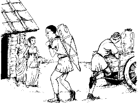
|
| The transportation of wine from a boat at Heybridge to the Limebrook Way Roman farm by Ox cart would have been the last stage of a long journey from the south of Spain. |
A few corroded bronze coins have been discovered but are difficult to identify. One is of Emperor Domitian (c AD85). Other small metal finds include fragments of brooches, a bronze stud and a twisted wire bracelet.
Utilitarian objects which could not be manufactured locally also had to be acquired from distant places. Fragments of Hertfordshire pudding stone from the Maldon farm site were once colourful grindstones. These important items of kitchen equipment were a source of pride and drudge to many a Roman nose!
Several animal jawbones, mostly ox, have been found in ditch fills, often at the very bottom. These were most likely discarded refuse although some contemporary sites have evidence of a ritual significance.
One cremation burial with pottery grave goods was found to the south east of the excavated settlement area. There was no opportunity for us to establish the presence of other burials in the vicinity.
Evidence of the actual buildings has been sparse and only circumstantial. Roman brick and roof tile fragments are common but not particularly plentiful. The presence of 'hypocaust box flue' tile fragments hints at the proximity of a centrally heated Roman house.
Unlike the settlement at Heybridge there is little evidence of the farm's occupation continuing much beyond the 2nd century AD. When the three centuries of farming ceased, the farm timber framed buildings were carefully dismantled so that materials such as roof tiles and timber beams could be used elsewhere.
Away from the settlement sites themselves, we have another important source of information - the surrounding countryside.
The Maldon farm site is at the edge of a regular pattern of fields whose alignment can be traced right across the Dengie Hundred as far as Burnham, Southminster and Bradwell. It has long been suspected that the field alignment dates back to Roman times but it has been very difficult to prove since so many of the field boundaries and roads are still in use today. Under the new Limebrook Way relief road was a long stretch of ditch, on the Dengie alignment, which clearly did not survive the Roman period.
By 250AD it had become silted up and was never cleared out. The most likely explanation is that Lime Brook and its adjacent long thin fields, which are not on the Dengie alignment, date back to the late Roman or Saxon period and has ever since preserved a strip of Roman landscape.
North of the River estuary, with the benefit of aerial cropmark photography over gravel subsoil, we also see a distinct but different sequence of land division in the Roman period. Regular rectangular fields can be traced but they do not conform to the huge pattern as do their southern counterparts. To the north we see Roman fields superimposed onto a truly ancient landscape dominated by meandering brooks and prehistoric trackways both making their way to the estuary salt marsh. The Roman intrusions in the north only lasted as long as the Roman way of life so that in Saxon times the small Roman field boundaries were abandoned and the people were quite happy to return to the older natural land divisions.
The Dengie clays had not attracted the prehistoric farmers and therefore did not have an ancient brook and trackway infrastructure. When the Roman workers cleared the land and established straight roads and regular fields the Dengie had become a practical place to farm for the first time. When the Romans left there was no going back, if the farming way of life was to continue on the clay, then the ditches had to be maintained. The people stayed and so the alignment survives to this day.
It is probably coincidental that life at the Limebrook Way farm site ceased at a time of unprecedented threat to the mighty Roman Empire. In the 3rd century, a combination of internal strife and fierce attacks from tribes against many frontiers led to a series of disasters and people began to think the unthinkable - Rome could fall. This was no new problem for Romans in Britain who had long been under attack as Hadrian's Wall and the numerous Saxon Shore forts, including one at nearby Bradwell, testify.
The provinces beyond the Rhine were irrevocably lost and areas of Greece and Italy were ravaged. Britain escaped the worst excesses that afflicted much of the rest of the Empire. Reconstruction and reform were effected by Diocletian and Constantine I, the latter recognising Christianity, hitherto persecuted, as the state religion and building a new capital, the city of Constantinople, which was to be the capital of the eastern Roman Empire or Byzantium.
In Roman Britain there followed a brief golden age. This ended abruptly in 342 when the Picts renewed their attacks in the north and the Saxons on the east coast. The capacity of Roman Britain to resist was seriously undermined by the conflict over the imperial throne and by corrupt and inefficient administration. Magnentius, a son of Constantine, withdrew troops from Britain to support his bid for the imperial title in 347. They were never replaced. Troops were withdrawn by Emperors to defend Italy.
In 383, Magnus Maximus, the military governor of Britain, revolted against the Emperor Gratian and crossed to Gaul with troops from Britain.
Until the end of the 4th century, the hordes of barbarians were just about kept at bay both in Britain and elsewhere but like the incoming tide on a sea shore which advances and then recedes only to advance further, each barbarian wave made deeper and deeper incursions. The Empire increasingly relied on barbarians known as Foederati or Treaty Troops, to make up its armies. The last great Roman general, Stilicho, was a member of the German tribe of Vandals. He restored the situation but it was only a brief respite.
The 5th century was to bring the disaster that had long been threatened. Stilicho left in 401 and took, in the words of Claudian, a court poet, '....the legion that protects the remotest Britons, rules the fierce Scots and scars the forms tattooed on the bloodless skin of the dying Pict'. The remaining forces were incapable of resisting the invaders. They became recruiting grounds for those who sought to seize the imperial throne. However, the plight of Roman Britain only reflected the plight of the Empire as a whole. In 410, Rome itself was sacked by the Visigoths. It was no surprise, therefore, that Emperor Honorius replied to the appeal from Britain with the words which signalled the end of the Roman Empire in Britain, '....the cantons should take steps to defend themselves.'
| Mealdune Contents | Maldon Archaeological Reports Home | Next section..... |