|
|

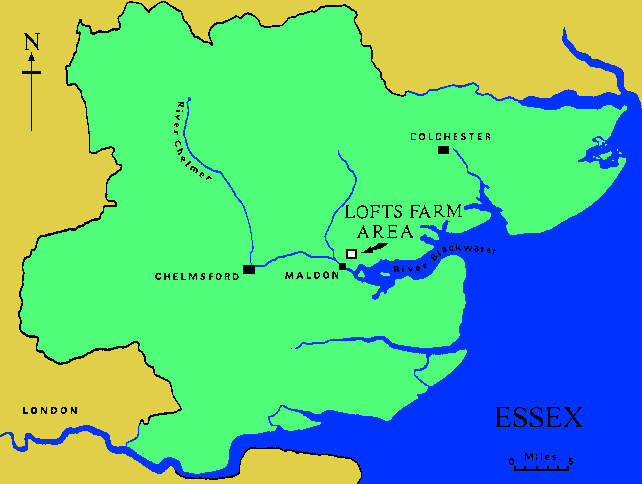
LOFTS FARM PROJECT - INTERIM 1978-79A ten-year gravel extraction programme around Lofts Farm, Great Totham (TL86670906) will destroy a complex of archaeological crop mark features. Contractors Aggregates, the gravel company, have allowed members of Maldon Archaeological Group to observe and work on the site as extraction progresses. At the end of our project's first year this is a suitable point to report on our results.
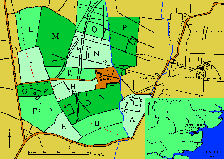
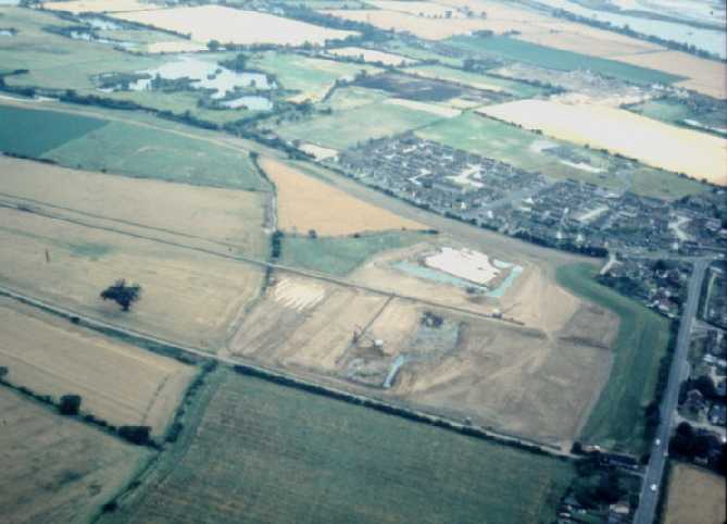
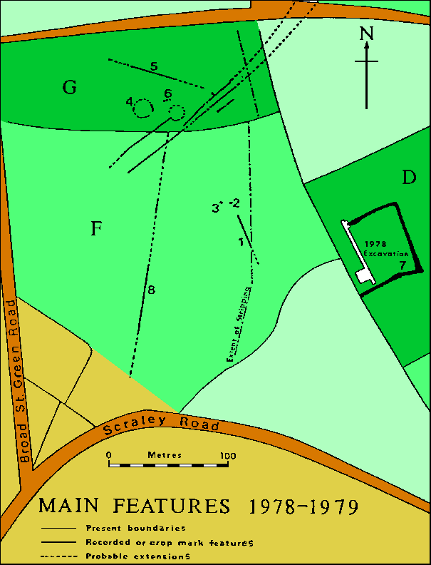
LOCATIONThe gravel terrace now being exploited extends along much of the north side of the Blackwater Estuary. The area that concerns us is approximately 1 km from the nearest sea wall and 2 km from the centre of Maldon. A layer of brickearth, sufficiently thick to prevent crop marks showing, covers the southern part of the site. Each field has been designated a letter as shown on the above plan. METHODSOur first year's work has included historical research, plotting crop marks from air photographs, excavation, field walking as well as the observation and recording after topsoil stripping of ten acres in the SW corner of the quarry. HISTORICAL RESEARCHA rental of 1441 refers to Loftes and is our earliest mention of the farm. Some earlier documents in the Essex Record Office may provide more references but they are at present in a too fragile condition to consult. Johnson, in his 1831 History of Great Totham, tells us about the owners and occupiers of the Lofts estate. It belonged to Anne Bourchier in 1570 when it was described as having 40 acres of arable land, 4 acres of meadow, 100 acres of pasture and 10 acres of wood in Great and Little Totham. John Bullock, who lived and was buried at Wigborough, owned Lofts in 1595. The head of this family was described as being "of Lofts" until 1637 when Edward Bullock bought Faulkbourne. The last Mr. Bullock died in 1705 and this may have been when the property was sold to Sir Nathan Wright of Cranham who was the owner in 1712. An Indenture of 1715 (ERO. D/DSU T72) details conditions of a lease between Nathan Wright and Phillip Good of Heybridge and informs us that the occupier of Lofts at the time was John Warwick. The document also gives a little insight into the nature of the property when it mentions 'a capital messuage or farm called Lofts', two other messuages or farms, a garden, a moat, a Hall, a stable, a coach house, a mead called Lofts Mead and a Hop Garden. Lofts was eventually bought, along with other land at Langford, by Nicholas Wescombe Esq. of Nottinghamshire. George Johnson in 1831 writes "The house at the time it was inhabited by the Bullock family, and even until within a few years past, was a mansion of considerable extent; the hall was particularly spacious. It was moated. A modern structure has been lately erected, and Is now a good farm house." From cartographic and field name evidence we know that in 1777 at least 10 acres of woodland existed on the southern part of the area and by 1839 it had disappeared. Perhaps the demand for timber and arable land during the Napoleonic "scare" was responsible for this. Our research work will continue In the hope of gaining a fuller understanding of the present field layout and the relationship of Lofts Farm to the 'moat' feature in field D. AIR PHOTOGRAPHIC EVIDENCEThe rectilinear enclosure shown in field A was not Initially recorded on the County Sites & Monuments Record and had been destroyed before we were aware of the gravel extraction work. It is in this field that Contractors Aggregates have set up their processing plant. A north-south trackway running at right angles to the river estuary is the site's most prominent feature and in field N can be seen other features directly related to this. These are a rectangular enclosure on the east side, a circular enclosure on the west and a possible junction and fork of another trackway off to the south-west. Apparently overlying the trackway ditches is a system of possibly regular rectangular fields with which a large well defined ring ditch is associated. Unrelated to the fields is an interesting bivallate enclosure in field P. The other obvious features can be seen in field D. A 'moat' shaped enclosure adjoins a field boundary and a line crosses the trackway from NW-SE. The latter corresponds to a field boundary shown on the 1839 tithe map. EXCAVATIONThe proposed order of gravel extraction is from the SW corner to the SE and then from the NW corner to the NE. Consequently the first known feature to be destroyed will be the 'moat' enclosure in field D. With this in mind M.A.G. successfully sought permission to carry out trial excavation work in the 'moat' area. An interim report of work is appended to the end of this account. FIELD WALKINGThe present intensive use of the arable land and our occupation with observation of top soil stripping has limited our field walking to one part of field D. It is difficult to deduce much from such a small sample, 6000 sq m, but we did find a greater concentration of medieval pottery at the 'moat' end of the field. OBSERVATION OF OVERBURDEN STRIPPINGWe have been rewarded with some important discoveries in an area which had not previously revealed anything by crop marks. The area cleared includes most of field F and all of field G and represents Stage One in the Gravel Extraction Programme. NEOLITHICOne of the County's largest collections of Middle Neolithic pottery has been rescued from two features, one being a straight thirty metre length of ditch and the other a small pit. Carbon dating and environmental evidence should be forthcoming from samples taken of the pit fill. Both features contained a few flint flake implements similar to those found earlier while excavating on the 'moat' site 100 metres away. Possibly related to this period were two or three shallow charcoal-rich pits approximately 1 metre in diameter. They were cut about 25 cm into the 'natural' brickearth that had been lightly baked red indicating burning in situ. No flint flakes or pottery were found. BRONZE AGENo Beaker shards or other Early or Middle Bronze Age finds have yet been identified, however, the Late Bronze Age - Early Iron Age is represented by a deep clay-lined pit which contained several flinty shards, some of which were very fragile. IRON AGEFour features containing Iron Age pottery were recorded in field G - a hut circle, a straight field ditch and two pits.
HUT CIRCLELimited time and resources allowed only a third of the hut circle to be fully examined. The drip gully ditch was unusual for its rather large diameter (16 metres) and also in the way it was interrupted frequently and neatly along its length. Near to, and at the centre, were two small postholes that seemed insufficient to have held roof-bearing timbers. Also at the centre, and on what must have been the top of the brickearth subsoil, was a concentration of pebbles that could have formed a plinth for a much more substantial post. No other postholes were observed in the section examined nor were any found outside the entrance. Possible evidence of roof timbers was recognised in the form of small holes at approximately 50 cm intervals around the outside edge of the gully in one section excavated. On the north and south sides of the circle the gully showed signs of disturbance. This could be interpreted as a recut but its shallow depth and patchy nature suggests that it could have been disturbance caused by the collapse of the hut's roof. Understandably, the butt ends adjacent to the east facing entrance produced the bulk of the finds. This contrasts with a section excavated opposite the entrance which did not produce one sherd. In addition to pottery, fragments of triangular loom weights and a spindle whorl were found. The hand-made pottery is comparable with types from the Little Waltham settlement site where these were dated between 300 BC and 50 BC. Decoration is limited to finger impressions on rims although there are sherds of a black sandy fabric with haphazard thin incised lines.
TRACKWAYThe two parallel cropmark ditch lines in field N, forking away from the main N-S trackway, were identified and traced across field G into F. A tiny fragment of pottery, too small to identify, is the only find from either of these ditches. Part of a ring ditch that appeared to be joined to one of the 'trackway' ditches was uncovered but then unfortunately destroyed between our visits to the site. It had been hoped that the straight Iron Age ditch would help resolve the 'trackway' dating but again we were not quite able to prove the connection. One ditch passes within 20 metres of the Iron Age hut circle but no pottery was found in the fill. This negative evidence suggests the two features were not contemporary. Positive dating must await the discovery of more evidence. CREMATION BURIAL PITA small pit containing charcoal and burnt bone fragments was recorded in field F but no indication of its date was recovered. Later study of the contents may produce the answer. SUMMARYOur work has shown that this gravel terrace had been used extensively, although not intensively, by man for over 4000 years, taking advantage of the good natural drainage for crops and the nearby salt marsh for grazing. It is likely that the Iron Age inhabitants were involved in the seasonal extraction of salt from the estuary although only one possible piece of briquetage was found in the hut area. A basic chronological sequence for the crop marks is beginning to emerge although it must remain conjectural until more positive evidence is recovered. This is the order - the trackway (?Bronze Age) - a system of rectangular fields (Middle Iron Age through into the Roman Period) - abandonment, represented by loss of the rectangular fields (?Saxon) - present field layout (?Early Medieval). The machine stripping of the topsoil showed that the hut circle was probably isolated as a settlement of this period would have produced a mass of pottery and this was not evident here. Considering some of the difficulties faced during the year - which included the driest autumn and the worst winter for some time, the results have been encouraging. Mr Rees, farmer of the fields to the north of Lofts, has generously offered to leave an area available to the Group for a whole year. This will enable us to excavate a selected area in detail. ACKNOWLEDGEMENTSWe are grateful to the gravel company, Contractors Aggregates, and the farmers, Mr. Hughes and Mr. Rees, for their permission to carry out our work on the site. The Essex County Council archaeological section have provided invaluable help in all aspects of the work. This included finance for machine stripping on the moat excavation, the loan of tools and equipment, and useful advice during the fieldwork and post-excavation work. |


|
|