LOFTS FARM PROJECT - INTERIM 1981-83
The Lofts Farm Gravel Pit has now extended another forty acres to the north,
and in doing so has probably uncovered the site's most concentrated and prolific
archaeological remains. This interim report gives a summary of the work and then
discusses certain discoveries In more detail. Most of the 1981-2 discoveries
were the result of a selective excavation at the centre of the field 'N'. The
rest came as a result of observation of topsoil stripping. Frequently last year
we were unable to investigate in detail all that was revealed and were forced to
be selective. We chose to concentrate on obvious structures, e.g. ring ditches
and post structures. Consequently many small, less obvious pits have been lost,
unrecorded.
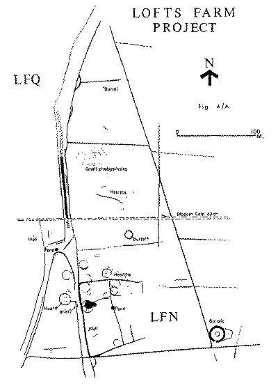
BRONZE AGE. (2,000 BC - 500 BC)
Three independent features were noted, a small well, a bucket urn burial and
an eleven metre ring ditch. Although not proven by finds this was probably the
last remnant of a barrow burial. More features may be attributed to the Bronze
Age when all the pottery has been thoroughly examined.
IRON AGE. (500 BC - 43 AD)
The Iron Age occupation is probably two settlements. The northern one, which
is the slightly higher and earlier of the two, is characterised by small groups
of pits and hearths. Traces of only one 7m. diameter ring ditch were found in
this area. Nearby a rectangular posthole structure, measuring approximately 5m x 8m
was planned but did not produce finds. Also In this vicinity were several small
oval pits which were not excavated. Four-post structures were also found in this
settlement. The pottery was coarse, fragile and devoid of decoration. From such
fragmentary remains it is difficult to understand the extent, or nature of the
settlement represented.
The habitation to the south, with its fourteen ring
ditches and distinctive pottery styles, is much easier to understand. This was a
farming settlement spanning the last two or three centuries before the Claudian
Invasion. Probably only one or two of the hut features existed at any one time.
They varied in diameter from 2.5m to 15m and most had an east-facing entrance.
one of the later (Belgic) structures is represented by a large pear shaped
depression rather than a ring ditch. An enclosure approximately 90m x 50m is aligned
onto part of the trackway and envelopes some of the huts. It was extended and
sub-divided in its later use. Apparently access was from the east, not from the
trackway. Other features of note were a 5 metre diameter pond, a small well and
four post structures. An elongated pit was found adjacent to an area of burning
in the top of a silted trackway ditch. There was some evidence to suggest these
were linked by a small tunnel and used together as a drier of some kind. At the bottom of the late enclosure ditches, we recovered
two examples of broken Belgic
pots with traces of burnt bone fragments, reminiscent of cremation burials. The
only other burial evidence from this southern area was an isolated (unstratified)
patch of charcoal and specks of cremated bone. Inside the circumference of a
pre-Belgic hut drainage gully we excavated 'en bloc' a small hoard of bronze
pieces. We suspect that the hoard was hidden by a bronze smith toward the end of
the settlement's life and later than the nearby hut.
ROMAN. (43 AD - 410 AD)
All the Roman evidence relates to the trackway and the
field ditches aligned on it. A 5m diameter pond, situated inside the trackway
junction produced Roman sherds. Two coins, one of Antoninus Pius (138 - 161 AD)
and the other a Barbarous Radiate (Circa 300 AD), were discovered by the use of
a metal detector over and near to the trackway.
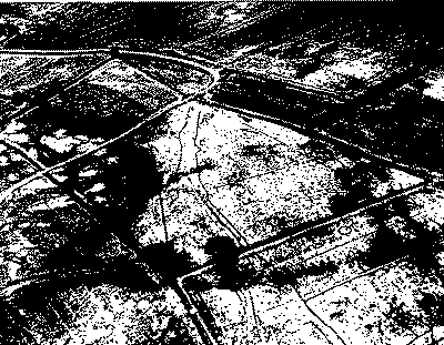
THE TRACKWAY
This most prominent feature ran north/south, right across the site. For much
of its length it consists of at least three ditches. Two of these were less than
three metres apart, resulting in a profile similar to the straight trackway to
the south of Lofts Farm and to a Roman road recorded in Colchester - (A.F. Hall.
JBAA 3S Vol. V11 1942 53 -70). Despite the lack of stratigraphic evidence, I am
confident that this configuration is not accidental. It is interesting to
consider possible causes. Does this smaller inner ditch mark off a footway? Is
it derived from a Roman scheme to reduce or standardise tracking widths?
Several other phases were visible including a series of protrusions on the
east side. These appeared to line up with field ditches. The trackway probably
existed before the first early Iron Age Settlements and may well have survived
until the 18th century AD. There is evidence for a link between the vestiges of
this ancient trackway, and an existing farm track which is used at present, and
extends northwards from our site. If this is so, and the ancient and modern farm
tracks originally formed part of a continuous route, then the existing modern
track may very well have been In use continuously for 2,500 years.
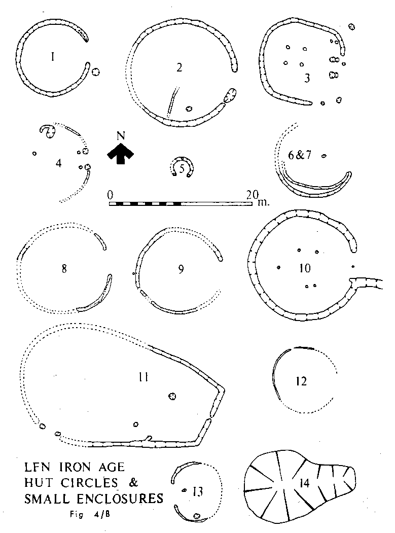
HUT CIRCLES
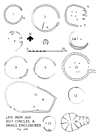
It is probable that most circles, if not all, represented a hut of some kind.
The pottery has not yet been carefully examined but it is already possible to
tentatively arrange them chronologically as shown above. Circle 1 was a
foundation trench for upright timbers. It had a hearth just outside the
entrance. The ditch of Hut '2' was probably a drainage gully around the outside.
The hut had an internal hearth and partition wall trench. The four post
structure in ENCLOSURE '3' is probably not contemporary. HUT '8' had the charcoal
remains of a ground timber plate. This beam slot design probably applies to huts
'6'. '7' and '9', but not to '10' which had an outside drainage gully. The
ditches of '4', '12' and '13' were very narrow and most likely housed a wall of
'stake' like timbers.
Much of '11' is conjectural and probably does not represent one building.
Finds in the excavated sections were few and far between. It is possible that we
did not notice this late re-cut when excavating the top of the comparatively
deep 'barrow' ditch. This suggested plan would explain why post holes were
recorded cutting through the top fills of the 'barrow' ditch, each side of the
causeway entrance.
Only one ('10') of these circles were clearly visible in the best cropmark
photographs.
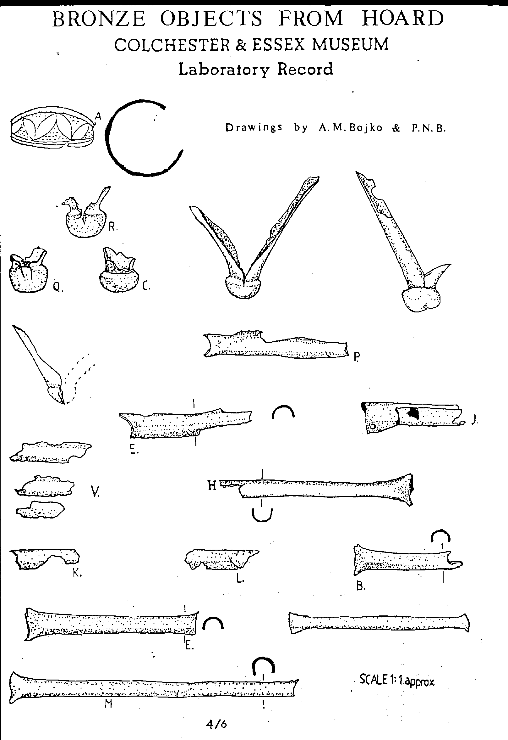
HOARD
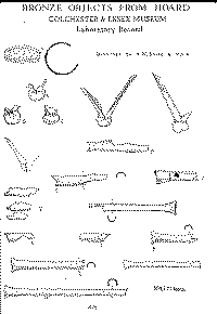
The hoard was entirely within 4 cm of the top-soil and may well have been dug
away by our own hired JCB had we not been alerted to its presence by the use of
a metal detector by a Group member before machine stripping began. We excavated
the delicate pieces in a "block" which could then be examined in
laboratory conditions at Colchester Castle Museum. This was achieved by digging
all round the hoard, making a wooden box to size, filling the edges with plaster
of paris and then undercutting. Before its 17 mile trip to Colchester we were
able to obtain an excellent X-ray picture of the hoard from our local hospital.
Several full-size prints from this X-ray were provided at a nominal charge by
Maldon's main photographic business. These have been of great assistance in
later examination and research work.
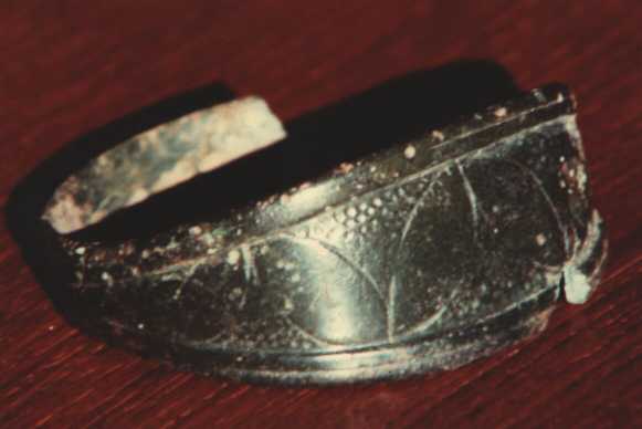
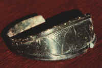
The hoard consisted mainly of 'Bredon' type IVa scabbard chapes and U-section
scabbard bindings. Also included was a small bronze ring. Part of the flat
surface of this had been widened to take punched decoration in the form of
interlocking arcs in La Tene style. A ball of grey substance, found with the
metal objects, has yet to be identified.
ACKNOWLEDGEMENTS
Again we are indebted to Mr. Rees who allowed us to excavated at the centre
of a cultivated field prior to the gravel extraction, and also to Contractors
Aggregates who have provided assistance to us wherever possible. The Increase In
discoveries has meant a greater need for expert assistance and advice. This has
been freely provided by The Essex County Council Archaeological Section,
Colchester & Essex Museum, and Stephen Greep of Verulamium Museum. We are
grateful for the financial help given to us, during this period, by the
following:
None of these discoveries would have been made had it not been for the hours
or toil put in by many members and friends of the Group. These Include: David
& Richard Jennings, Gillea Crossley, Elaine Brown, Stephen Nunn, Brian
Chinnery, Geof and Pauline Clark, W.J.R. Clark, Anna Cronin, Betty Watts, Philip
Brown, Lesley Bermingham, Pat Ryan, Betty Andrews, Mark Harvey, Allen Wyatt, Len
Sargent, Colin Langmead, Bob Adams, Kelvin Adkins, Rowland Flook. David Hurd,
Mike Stitchbury, Mark Billage, Dave Gustard, Brian Milton, Tony Doe.
Doug Renton, worked full time on the site for several weeks. He is
responsible for the clarification of important features which would otherwise
have been lost. The metal detecting, site observation, recording and excavation
carried out by Pat Adkins also made a significant contribution to our knowledge.
Those who have played important parts in the post excavation work include: Garth
Groombridge, Tony Froom, Mike Crellin, Martin O'Connor, Eric Doherty.
Paul N. Brown - Chairman Maldon Archaeological Group