HOW THE PIECES FIT TOGETHER
So what sort of picture can we construct with our jigsaw pieces and have we found King Edward's Burh?
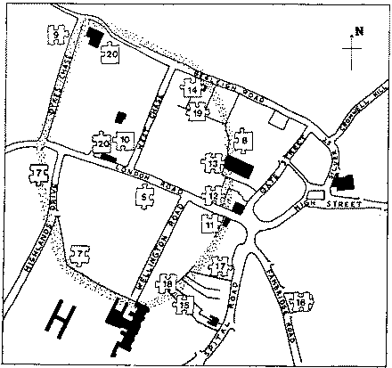
There is now little doubt that we have identified the earthworks sketched by Strutt two hundred years ago. If we disregard Salmon's twenty-two acres as an error of judgement then this earthworks is also his 'camp on the west side of town'. Both believed this to have been the Saxon fort. It has to be admitted that we still lack archaeological proof of the late Saxon involvement from any site but find the overall weight of evidence tends to support the antiquarian's assumption.
|
STRUTT'S 1775 PLAN
|
Our picture of the hilltop prior to Edward's visits is also tantalising. We now have sufficient proof to indicate significant occupation in the early Iron Age but lack conclusive proof from earthworks that a hillfort existed.
There are some jigsaw pieces which do not appear to fit our (and Strutt's) picture of the burh. One is Salmon's twenty-two acres which has been discussed earlier. Another is the notion that the Ware Pond in Spital Road, is a remnant of the Saxon Burh. The Pond does not coincide with our circuit but it could be related to associated earthworks. In any case water would permeate along the line of the backfilled ditch in Spital Road and certainly end up in any lower depression such as that formed by the Ware Pond.
Clearly we still have much to learn of Maldon's early history and will continue to search for clues. In particular we might look for additional earthworks which could have protected the town itself against Viking attack. There is still a need for a thorough topographical survey which could lead to the solution of important questions. e.g. Did the main Burh ditch act as a moat?. The survey would also give us more understanding of the existing map evidence. A closer study of tithe award areas may resolve Salmon's twenty-two acre mystery or clarify the relationship of All Saints Parish boundary to the burh. Yet another useful 'non-excavation' task would be to carry out a resitivity survey to detect an additional ditch to explain Strutt's 20 yard ditch measurement. This would involve the insertion of electrical probes into the ground and taking a series of resistance measurements.
MALDON'S PAST - A NEW PERSPECTIVE?
Maldon Archaeological Group have not made any startling new discoveries or are we proposing any major changes to ideas suggested many years ago. However, we do now feel there is sufficient evidence to retell the story as one of probability rather than just possibility. It would appear that the story of the hilltop fort is very much linked to the story of Maldon the town.
We begin around 600 BC, at the end of the Bronze Age in troubled times when heavily defended settlements were a common necessity throughout the continent. Maldon would have been a choice site with its spacious flat top, steep slopes on two sides and its strong strategic position overlooking the river estuary. The prominence of other contemporary sites overlooking the valley, such as Danbury Camp and Springfield Lyons, suggest that the river played a much bigger part in the lives of these ancients than it does in ours. Other attractions would have been its proximity to the open sea, to salt marsh, and to good arable land on gravel terraces.
Lowland settlements are notoriously difficult to identify, probably due to the sparseness of evidence left by their post constructed round houses. An unusual double ditch enclosure with a central round house was recently excavated near Lofts Farm, Gt. Totham.
Life eventually became more peaceful and in the middle Iron Age (300 - 50 BC.) we see a big increase in undefended settlements and field systems in the surrounding countryside (see Lofts Farm Project Interim Reports) coinciding and contrasting with a total lack of evidence from the top of the hill. Maldon's initial significance must have become irrelevant and so the site remained unoccupied for centuries.
With the arrival of the Romans the hilltop once more became of strategic interest (see jigsaw piece 19). It became in some way occupied and may have been regarded a 'no go' area as far as the local inhabitants were concerned.
It is not unusual to find the first Saxon immigrants settling on rough land just outside a Roman town. These were often the same areas used by the town's people for unpleasant or dangerous industries or for burials which were not permitted inside the town itself. If this happened by Maldon 'fort' then it might explain why the Saxon and later town's focus is around the present day All Saints Church area, rather than inside the ancient earthwork. Against this proposition is the lack of any archaeological proof! There has been evidence of a settlement at Heybridge in early Saxon times and the possibility of intensive industrial iron working near Chigborough Farm. Like their Bronze Age predecessors the Saxon's material remains are also difficult to detect.
Well before the 10th century Chronicle references, Maldon had become an important town. If we discount the above 'Roman connection' then we have yet to discover an approximate date or reason for the town's foundation in middle Saxon times. In the 'Dark Ages' the hilltop again lost its strategic importance and again lay empty for many years.
A deserted hillfort would have been an ideal place for King Edward during his campaigns against the Danes. He may have been uncertain of the townsfolk who had been under Danish rule for four years. During the tenth century, Maldon, with it's Royal connections and mint probably enjoyed the zenith of it's power and influence.
After the defeat of Byrhtnoth in 991 the fort must have again lost some, if not all its military significance although the town itself continued to flourish and was shown to be the second most important Essex town in the Domesday Survey of 1086. Royal Charters from 1171 show that during the medieval period, Maldon continued to enjoy privileges as an important historic town although its status in the county declined gradually.
Even after 1500 AD. Maldon still retained some of it's early privileges. The
town centre as we know it today is basically the medieval townscape surviving
thanks to the preservation of many ancient and varied buildings. Despite the
handicap to archaeological investigation below ground! these buildings are a
tremendous asset to the town and we hope they will survive to enrich the lives
of many more generations.
Finally, it is fascinating to note the use of the 'burh' area at the time of
the Napoleonic invasion scare. As pointed out earlier we do not yet know the
extent of the Maldon barracks, but once more we see the hilltop becoming used
in fearful times, just as it had done so long ago.
ACKNOWLEDGEMENTS
Over the years the Group's 'burh hunt' has received help from a large number of individuals and several organisations. We are particularly indebted to the Thorneloe family for allowing us to carry out the important excavation at 20 Spital Road. Excavations at 5a and 33 Beeleigh Road also provided much useful evidence and we are grateful to Mr. and Mrs. M Feeney and Mr. C Dixon respectively for allowing those investigations. We also thank Mrs Muriel Binder, of Newtrees, for her interest in the project and for allowing us to survey through her garden.
The generous support and interest of professionals in our work is of great help and an encouragement. We are indebted to Mike Eddy, a M.A.G member and formerly of the Essex County Council Archaeology Section, for his help in the formation of our Burh Research Committee and the direction of the Beeleigh Road excavations. We thank Carol Cunningham and Nick Wickenden of Chelmsford Archaeological Trust and specialists in the Essex County Council Section for help with pottery identification, also David Andrews of the E.C.C. Archaeology Section for his advice and help in the preparation of this report.
During the difficult time of the Beeleigh Road excavations we were joined by an enthusiastic group of volunteers from the Brain Valley Archaeological Society, led by John Hope. Thanks to their help we were able to rescue much more than we could have done alone.
Maldon District Council's continued support has provided grant aid for the Beeleigh Road excavations and assistance with our accommodation. Such 'back up' support is vital to the long term value of our efforts past, present and future. Tesco Stores Ltd. Maldon have provided numerous paper bags for finds storage, a small but valued contribution to the work. Lloyds Bank PLC., through their national award fund for independent archaeologists, have assisted by awarding us electric pumping equipment and have recently awarded us the funds to allow finds from the Spital Road ditch to be scientifically dated.
My thanks go to the M.A.G. members who played special parts in the 'Jigsaw' story. To Allen Wyatt who set things moving at 20 Spital Road and has organised the finds processing, John Avent for taking a lion's share of the digging and section drawing, Derek Punchard for organising assistance from Plume School pupils, Stephen Nunn for help with digging and this report, Geoff Clark for photographic cover, Barbara Smith for digging and work on the Tithe maps, Martin O'Connor and Mike Crellin for report duplication and Garth Groombridge for finds processing.
Many others have contributed to the M.A.G. effort over the years and include David and Richard Jennings, Susan Wade, Mick Bell, Brian Chinnery, Betty Andrews, Gillea Crossley, Anna Cronin, David Gustard, Tony Plumridge, John Stocker, May Marigold, Tony Froom, Bob Adams, Doug Renton, Nobby Clark, Len Sargent, Pat Sheehy, Phil Gollin, Anne Gray, Samantha Skingsley, Ivan Jeleff, Elaine and Jonathan Brown, Michelle Mayes, Wendy Galletti and Tony Doe.
PAUL N. BROWN JULY 1986
BIBLIOGRAPHY
- S. Bassett - Youth Hostel Site, Interim Report (1973)
- S. Bassett - Tesco site, Interim Report (1971)
- 1. Chaulkley-Gould - Trans. Essex Archaeological Society. Vol.X (1909)
- K. Crossley-Holland and B Mitchell - The Battle of Maldon and Other Old English Poems (1967)
- P.J. Drury - Heybridge Excavations - Interim Report
- P.J. Drury & N.P. Wickenden -Heybridge Saxon Settlement- Medieval Archaeology Vol. xxvi, 1982.
- M.R. Eddy - 68 High St - Interim Report (1978)
- E.A. Fitch - Maldon and the River Blackwater (1898)
- G.N. Garmonsway - The Anglo-Saxon Chronicle (1972)
- F.H. Laws - Maldon a Thousand Years Ago (1952)
- Maldon Archaeological Group - Ecclesiastical Monuments of Maldon Project. Interim Reports 1 - 8, 1983 - 1986. Compiled by Stephen P. Nunn.
- Maldon Archaeological Group - Lofts Farm Project - Interim reports -Compiled by Paul N. Brown
- S. Morris & D.G. Buckley - Excavations at Danbury Camp - Essex Archaeology & History Vol.10. (1978)
- Anne Savage - The Anglo-Saxon Chronicles (1983)

|
|

|