Maeldune - Light on Maldon's Distant Past
Barbara Smith
THE one thing we do know about the site of the historic Battle of Maldon is that we are unlikely to discover it using straightforward archaeological excavation techniques. We cannot be certain that any clues at all have been left behind in the ground for us to find. No fort or defensive earthworks are mentioned in ancient accounts of the Battle and metal was too precious a commodity in Saxon times for arms and armour to be left behind on the battlefield.
It was usual for the victorious army to strip the dead of all metal objects, valuables and clothing. Where a town was sacked and burned, not even the church would have been spared from the Vikings greed, although we do not have any evidence that this happened at Maldon.
The Saxons who fled the battle-field would have taken their weapons with them. A Saxon's most prized possession was his sword, as it implied standing and wealth. The great majority of Anglo-Saxons fought with spear and shield. These were mainly constructed of wood, with few metal parts remaining in the soil for us to discover.
Hoards found on other sites, believed to be destined to become danegeld, have frequently consisted not only of coins, but also buckles, brooches and pins, and other objects of precious metal. The Vikings did not seek coinage (money) but gold and silver, the 'international currency' of the time.
That a battle took place is a matter of historical fact, recorded in various contemporary works and discussed in Chapter III. Local interest is most likely to be concerned with the location of the site of the battle. However notable the events recorded in the documents of the past, people need a tangible and identifiable context. For most of them it is important and much more satisfying to be able to identify the spot where events great and small occurred. If the site of the battle was recorded it has long been forgotten or lost. Many scholars and antiquarians have pondered the whereabouts of the site in recent history, notably Dr E D Laborde (1925), E A Fitch (1894) and P Morant(1768).
For many years Dr Laborde's conclusion that the battle took place just south of the Northey Island causeway has been widely accepted. Indeed the Ordnance Survey maps show this as the battle site. However, M.A.G. felt several other sites in the Maldon area were worthy of investigation and a number of archaeological techniques were used to study each one. Although in no case was digging employed, a lot of useful information came to light.
The starting point for our investigation had to be the poem. However, this had to be treated with a certain amount of caution. The poet is unknown but it is possible that, like the commemorative tapestry, it was commissioned after the battle by Byrhtnoth's widow, Aelfflaed. The poem as it survives is incomplete and does not mention Maldon or any other town. There are references to crossing Panta Stream, wading westwards and the river flooding the crossing place at high tide, and these gave us initial clues in our search.
The battle seems to have taken place alongside the river, at a crossing place accessible only at low tide. Most probably the shore area provided the only open area for a battle of the kind described, with ranks of foot soldiers lined up, firing showers of arrows and spears at one another.
The use of the word "Panta" in the poem is interesting, the Saxon word Pant means a valley. Phillip Morant writing 800 years later describes Maldon as overlooking Blackwater Bay. Certainly the river can hardly be described as flowing through a valley below Heybridge Basin. The River Blackwater is, however, still known as the River Pant above Braintree.
Could the battle have taken place above the river basin or bay? In the Laud Chronicle we are told that in 991 "Ipswich was harried and very soon afterwards Ealdorman Byrhtnoth was slain at Maldon". The Liber Eliensis (the Ely Book) tells us that Byrhtnoth fought the Danes twice in four years, with Byrhtnoth returning to Northumbria between the battles. When the Danes came to Maldon the second time they issued a challenge to the warrior who had formerly defeated them, which Byrhtnoth accepted, gathering his former comrades in arms around him.
It is not difficult to imagine Byrhtnoth and his men marching south along the old Roman road from Colchester to Maldon and looking across to the river to see the assembled Viking ships, swearing to rid Maldon of these Vikings once and for all. But where on the river were the Vikings? Did Byrhtnoth lure them away from their original camp to fight the battle on his chosen ground - perhaps in an attempt to protect the town or trap the over confident Danes into an error?
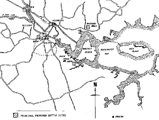
BARROW HILLS, GREAT TOTHAM. (TL078877)
In 'The History and Antiquities of The County of Essex' Morant noted that in 1768 there were in Totham parish, by the shore, many tumuli or mounds of earth, called Borough Hills, which seemed to be the graves of Danes or Saxons slain in assaulting and defending the area. Similarly in 'Maldon and the River Blackwater' (1898), Fitch noted that some of these tumuli were in Heybridge parish but the most noticeable were in that part of Great Totham "that runs down to Blackwater Bay"
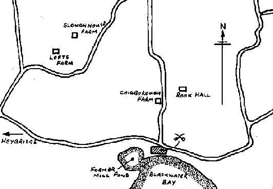
Both authors refer to the shore-line at Mill Beach. A mound was opened in 1773, but no antiquities were found. Possibly the mounds were soil heaps resulting from the digging of the mill pond for Heybridge Tide Mill built during the 18th century. Recent archaeological work at Chigborough Farm, Slough House Farm and Rook Hall have uncovered evidence of an extensive Saxon metal working or smelting industry. This would have provided a good dry encampment and site for footsoldiers to fight on. The valuable metal for swords and armour may well have attracted the Vikings as plunder. Having landed they may then have been attacked by the Saxons anxious not to let this valuable commodity fall into the enemies' hands.
HEYBRIDGE (TL081856)
Heybridge lies to the north of the River Pant and is reached from Maldon by crossing a medieval bridge.
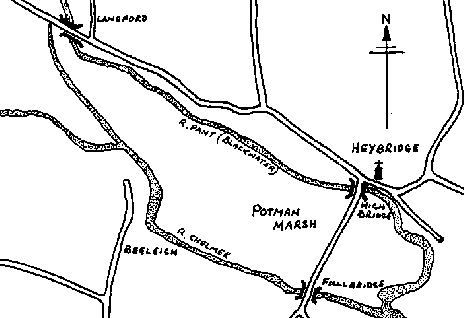
Fitch conjectures that the battle took place near St Andrew's Church, having noted that ...."Olaf or Anlaf finding it impossible to force the bridge defended by Wulfstan, crossed the tide at the ford westward towards Langford". E A Freeman in his 'History of the Norman Conquest' discusses the location of the battle and also locates it in this area.
It seems reasonable to assume the Vikings may have camped on Potman Marsh and fought the battle on the higher ground around the church.
In Saxon times Heybridge was known as Tidwoldington, from the Saxon "Tun" meaning farm or enclosure belonging to "Tidwold". However, by 1200 the name had changed to "Heaghbregge" meaning "High Bridge". This change of name may have been brought about by the construction of a new bridge. Certainly in 1324 King Edward II ordered a survey of the causeway across Potman Marsh to be carried out, giving some indication of the importance of this particular route. Alternatively, the change of name might have been to commemorate an event of some importance which occurred on or near the bridge.
Why, we must also ask, have all the villages surrounding Maldon, such as Langford and the Tothams, retained their names of Saxon origin, but Heybridge has not? Names sometimes change after a dramatic event, so is Heybridge trying to reveal something of its past history to us?
LANGFORD (TL090837)
The "Long Ford" of Saxon times, this village lies directly on the River Pant (Blackwater). It seems unlikely the Vikings could have sailed so far up river even in their shallow draft vessels. However, it is only a short distance across country westwards from Heybridge to Langford. If the Vikings had landed at Heybridge to plunder the metal-workings could Byrhtnoth have mounted a surprise attack, cut off the Vikings from their ships and driven them inland until they made a stand at Langford?
FULLBRIDGE (TL074851)
The Fullbridge lies at the other end of the causeway crossing Potman Marsh from Heybridge. First recorded in 1185 as "Fulebridge", meaning "Muddy Bridge", this is a crossing of the River Chelmer rather than of the Blackwater.
The land on either side was very marshy and unsuitable for foot soldiers. However, with the hill of Maldon rising on the southern bank, the river has the appearance of entering a valley.
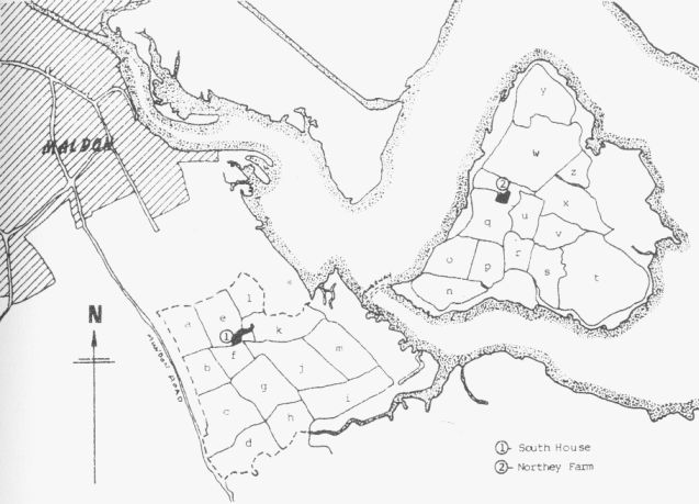
NORTHEY ISLAND/SOUTH HOUSE FARM (TL055865)
Following Dr E D Laborde's paper on the battle, published in 1925, this has become the accepted site of the battle in many peoples' eyes. Perhaps its wild desolation and unspoiled openness makes this an appealing choice over most other sites, which have, unfortunately, been disturbed by modern residential or industrial development.
A crossing to the island has existed since at least Saxon times as Domesday Book (1086) makes reference to Northey Island being used for cattle grazing. At first sight the present causeway is too wide for spears to have been thrown across and insults heard. In 1973 geologist Susan Petty, assisted by her father G R Petty, travelled from the U.S.A. to carry out a borehole survey of the causeway and surrounding land to establish the 991 topography.
They were able to establish that, whilst the saltings have been building up, the banks have been eroding to make the present channel approximately twice its 991 width of about 120 yards. Such a distance would have made shouted conversation and the flight of arrows perfectly feasible.
M.A.G. undertook a fieldwalk of the Hintersea and Furthersea fields (see map), in 1988. This involved group members walking across the newly ploughed fields at regularly spaced intervals and collecting all items of pottery, brick, metal or glass which could be seen on the surface. Items from the Neolithic, Iron Age and Roman periods were found but none from the Saxon period. This neither proves nor disproves the battle site, as the fields have been regularly ploughed over many years and any deposits would have been dispersed.
This fieldwalk was of use to us in a wider context, providing information about Roman use of the land for salt making, thus providing clues in our separate search for Roman Maldon.
We did not walk any other fields at this site as we felt they were too marshy to have been suitable ground for a battle. We were unable to walk any other sites because they have either been built over or are grass fields. Land needs to be ploughed to bring finds to the surface.
We are particulary grateful to E A Lane (Holbeach) Ltd and the National Trust for granting us permission to walk across their land and carry out our surveys in the vicinity of South House Farm.
The fieldnames themselves did not provide us with any clues, even the Stake Field on Northey Island probably owes its name to staking or marking out in small areas. Names also change regularly. We were able to study two estate maps, of 1822 and 1906 respectively, of Northey Island and many fields had changed their names in less than a century.
(Record Office Ref. D/DXA 23)
Mainland
|
Northey Island
|
Strategically the island would have provided a safe camp for the Vikings. There was little likelihood of the Saxons mounting a surprise attack. If the battle occurred here it would have had to have been fought on the mainland, probably in Furthersea Field.
The site is well away from the town and the industrial smelting area of the northern shore. If Byrhtnoth was trying to protect these two areas he may have seen the Vikings make camp and decided to blockade then on the island. If the Vikings had arrived at high tide they would not have seen the submerged causeway and could merely have been using the island to spy out the land before attacking the town.
We know Byrhtnoth's wife Aelfflead owned lands at Lawling and it would be only a short ride across country for the Saxon Thane and his men if they had been staying there, using the South House Farm area as their rallying point.
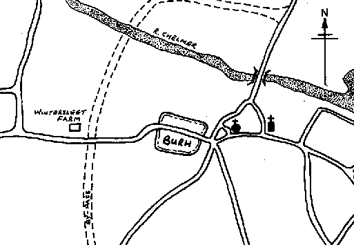
BEELEIGH/WINTERSLEET FARM (TL074846)
Our reasons for looking at this site began with local folk-lore, stories have long been told of a battle taking place in the area north of London Road near the town's western bypass.
This site fits the poems reference to the Vikings moving westwards from the crossing point, being westward of both river crossings between Maldon and Heybridge. It is also immediately north west of the Saxon Burh, whose probable location was traced by M.A.G. in 1986.
Wintersleet Farm lies on sloping ground between the Burh and the river, and the Pettys in their report on Northey Island causeway also pointed out that this was another site to be considered.
One argument against the choice of this site is that the river is not navigable at this point at low tide. But imagine the Vikings, arriving off the Burh, only to find themselves quickly beached on the mud. Could the famous spear throwing and speech making have been across Maldon's sticky mud. Have we found the origin of Maldon's Mud Race?
Centuries later this site was used by Roundhead soldiers during the Civil War as a camp, leaving evidence in the form of clay pipes. A natural spring exists in the area, making it an ideal camp site.
Across the road, what is now the Newnham Green housing development is built on the north-west facing brow and slope of Maldon's hill. Prior to building work commencing, M.A.G. and Essex County Council archaeologists were able to investigate the site. As well as unearthing prehistoric and early Medieval pottery we also discovered what a wonderful panoramic view any Burh defender would have had along the river.
If the Burh were used for its intended purpose, all people, animals and portable goods would have been rounded up and taken inside. The Vikings would have either attacked the encampment or laid siege to it, the latter not being very profitable to a raiding army. Knowing the Vikings would attack, the Saxons may have lured them to the base of the Burh to give greater weight to the shower of arrows they would have sent down on them. The Saxons would also have had the advantage of attacking downhill.
OSEA ISLAND (TL070891)
The choice of Osea Island has previously been dismissed, due to the claim that the causeway was too long. However, recent archaeological investigations into the Essex foreshore have revealed many settlements below the current high water mark. One of these, The Stumbles, is near Osea Island and had uncovered a Bronze Age wooden hurdle. We have no reason to suppose the area was not still in use in Saxon times, particularly in the light of the Petty's report that the river has changed somewhat over the centuries.
OTHER SITES
We should not forget that the Vikings probably raided along the river from Bradwell to Maldon. A plateau fort existed at Asheldham (TL013973) and Saxon pottery and weapons which appeared to be Viking were found when the surrounding ditch was excavated. The Roman fort of Othona at Bradwell (TM080035) had fallen into disrepair, the chapel of St Peter's on the Wall was built around 650 from reclaimed rubble. It may have been partly refortified in the light of the Viking raids along the coast.
All we really have are theories. Even if a sword or helmet are found they can not prove a battle site, merely that the Saxons and Vikings were here and that we already know from other sources. A mystery still surrounds the site of battle but as long as the poem is still read, people will hear the clash and shouts of battle and, perhaps, wield an imaginary sword to defend Maeldune.
| Mealdune Contents | Maldon Archaeological Reports Home | Next section..... |